
Derwentwater
& Catbells
A complete mile-by-mile route guide for runners and walkers
The route is circular, starting and finishing in the heart of Keswick, meaning you have the town’s cafés, pubs, and outdoor shops at both ends of your day. This is how the Derwentwater and Catbells circuit was designed to be run. Starting from the heart of Keswick at the Moot Hall — the 18th-century market building that has served as the town’s landmark and meeting point for over three centuries — the route heads immediately west, away from the lake, through Portinscale and out along the western shore of Derwentwater. The lake is to your left as you head south; Catbells rises ahead and to your right, its distinctive ridge growing larger with every passing mile.
The ascent begins properly at just over three miles, at the foot of Skelgill Bank below the northern ridge of Catbells. From here the climb is sustained and unrelenting — nearly 300 metres of ascent across two miles — with a short scramble near the top where hands meet rock. The summit at 447 metres arrives at roughly mile four, offering what Wainwright called a view matched by few others in England.
What follows is the descent into Manesty Park on the southern and eastern side of the fell, a rapid loss of height that brings you back to lake level before the long, flat, deeply satisfying return along the eastern shore — past Lodore Falls, through Calfclose Bay and Friar’s Crag, and back into Keswick from the south. It is a route of three clearly defined acts: the approach, the climb, and the homecoming.
Moot Hall to Portinscale
The route begins at the Moot Hall on Market Square — Keswick’s most recognisable building, its distinctive stone arch and one-handed clock familiar to every visitor. The current hall dates largely from 1813, though a market building has stood here since at least the 16th century. The one-handed clock is not, as often supposed, the result of Victorian parsimony — it was simply the original design when the clock was installed, single-hand mechanisms being common for tower clocks of that era.
From Moot Hall, head west through the town. The route follows roads and paths through Keswick’s western streets, dropping down toward the River Derwent. The town’s outdoor gear shops, cafés, and the buzz of Market Square are quickly left behind as the route passes through quieter residential streets toward the river. Hope Park lies to the south — a pleasant town park with bowling green and open lawn — as the path descends toward the suspension footbridge.
Point of Interest — Portinscale Suspension Bridge: The pedestrian suspension footbridge over the River Derwent connects Keswick to the village of Portinscale on the western bank. It bounces satisfyingly underfoot and offers clear views upstream toward the confluence of the River Greta — which drains St John’s in the Vale and Thirlmere — with the Derwent. The name Portinscale comes from Old Norse: likely “Porticus-skáli,” meaning a shelter or lean-to at a market crossing point, suggesting this was a trading place on the river even in Viking-age Cumbria.
Cross the bridge and follow the lane through Portinscale village — quiet stone cottages, the Derwentwater Hotel at the riverbank, and a general air of unhurried calm that marks it out from tourist Keswick a few hundred metres to the east. From the village, pick up the path heading southwest toward Nichol End and the northern reaches of the western shore.
Runner’s NoteYour warm-up mile. Mixed surfaces — road, path, bridge — at entirely flat elevation. Settle your breathing and resist pushing pace. You have a 450-metre mountain in front of you and nearly three miles of flat running before it begins.
Western Shore — Nichol End to Hawse End
From Portinscale the route enters the western shore woodland, heading south along the Cumbria Way long-distance path. The path passes through the estate grounds of Fawe Park and the approach to Nichol End, where a small marina sits at the northernmost point of the accessible lakeshore. The terrain is almost entirely flat, winding through mixed oak, ash and birch woodland with the lake appearing intermittently through the trees to your left.
This mile moves through the oak woodland that characterises Derwentwater’s western shore — ancient Atlantic sessile oaks draped with mosses and lichens, the woodland floor thick with ferns and wood sorrel. Red squirrels are present here and relatively frequently sighted, particularly in early morning. The woodland is part of a red squirrel conservation corridor extending the length of the western shore, one of the most important habitats for the species in northern England.
Point of Interest — Lingholm Estate & Beatrix Potter: The path skirts the edge of the Lingholm Estate, where Beatrix Potter spent nine summer holidays between 1885 and 1907. These Keswick summers were formative for her creative work — the oak woodland here directly inspired the backgrounds for Squirrel Nutkin (1903), and St Herbert’s Island in the lake became “Owl Island” in the same book. The Lingholm walled kitchen garden is now Lingholm Kitchen, one of the finest café stops in the Lake District. It lies a short detour off-route from approximately the 2.5-mile mark — worth considering for walkers wanting a proper stop before the ascent.
By the end of Mile 2, the path reaches the area of Hawse End, where the National Trust car park marks the most popular starting point for casual ascents of Catbells. The northern ridge of the fell rises steeply ahead. Having approached via Portinscale and the western shore rather than by car, you arrive at the foot of the fell with context and momentum — two miles already in the legs, the lake behind you, the mountain ahead.
Walker’s Note: Hawse End is an excellent point to reassess conditions and kit before the ascent. Ensure you have sufficient water — there are no reliable water sources on the fell above. The Keswick Launch stops at nearby jetties if you need to abort before the climb.
Skelgill Bank — The Ascent Begins
This mile is where the route’s character changes entirely. From Hawse End the path leaves the woodland and begins climbing the northern nose of Catbells along Skelgill Bank — the broad, well-worn ridge that forms the fell’s most popular ascent line. The path is clear and distinct throughout, engineered in its lower sections with stone pitching to manage the volume of feet it receives each year.
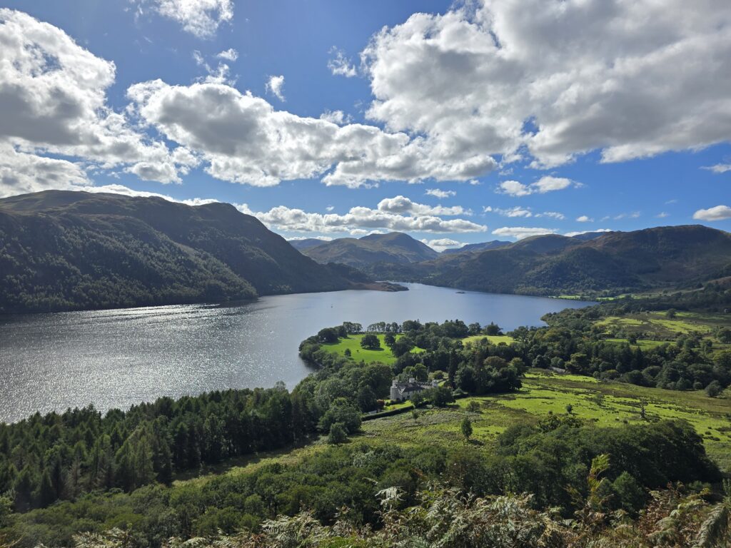
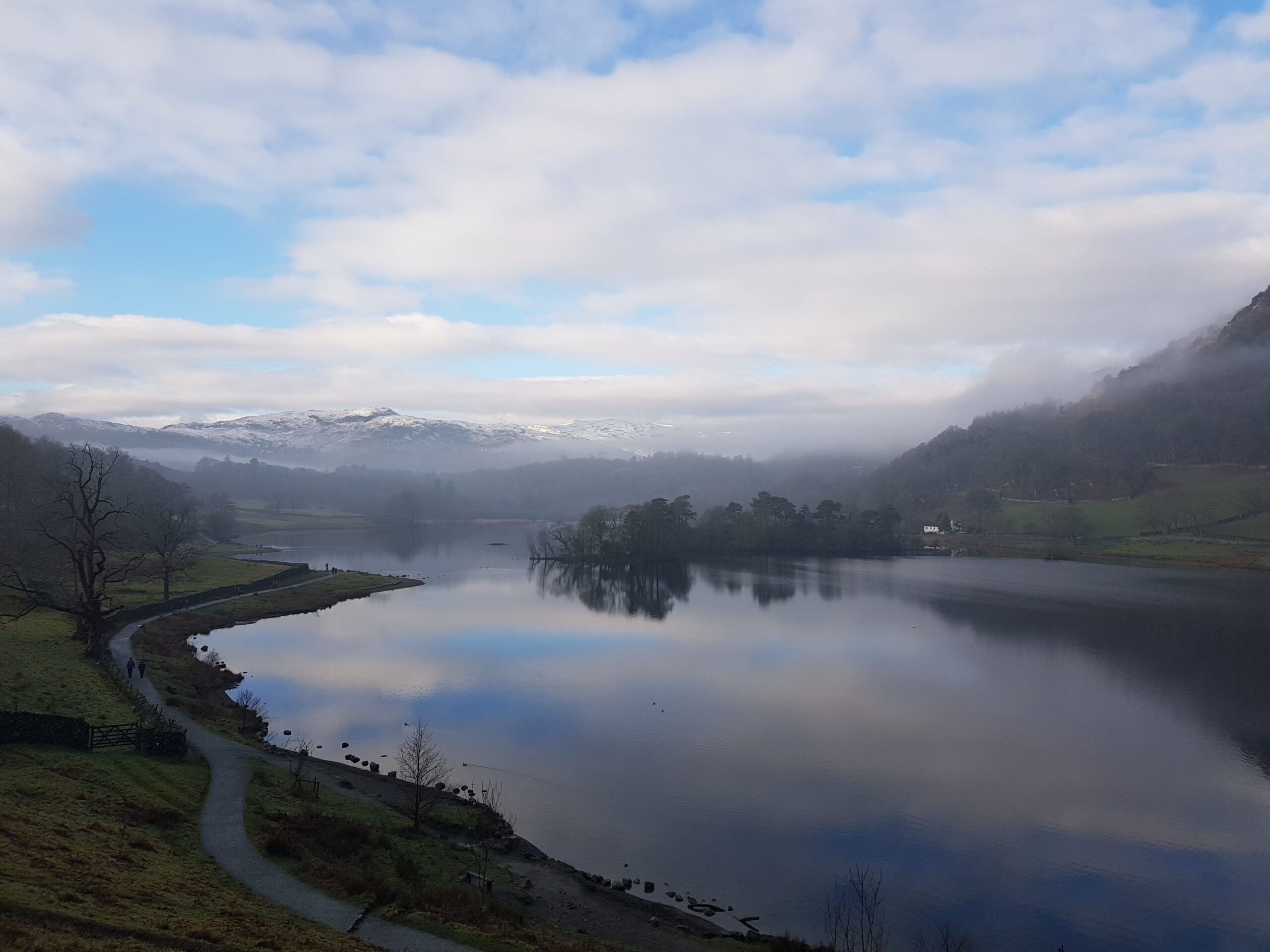
The climb gains approximately 120 metres across this mile, rising from the wooded shore at around 83 metres to the first significant shoulder at 199 metres — a point roughly halfway up the ridge where the gradient briefly eases before the steeper upper section. As height is gained, the views open dramatically northward: Derwentwater appears below you, its full northern extent visible, with Keswick at the far end and the massive bulk of Skiddaw (931m) rising beyond. The lake’s two northern islands — Derwent Isle and Lord’s Island — sit in the water directly below.
Point of Interest — Skelgill Bank & the View North: The view north from Skelgill Bank is one of the great progressive reveals in Lake District walking — with each step upward, more lake, more fell, more sky opens behind you. The panorama from the shoulder at 199m already encompasses Keswick, Derwentwater, the Skiddaw massif, and on clear days Bassenthwaite Lake to the north. This is the view that drew the Romantic poets and artists here in the late 18th century — Coleridge, Wordsworth, Southey, and later Ruskin all knew this fell.
The name Skelgill is pure Norse: “skál-gil,” meaning shelf-ravine or ledge-gully, a description of the terrain on the western side of the ridge where the fell drops sharply into a small valley. The farm at Skelgill below — one of the oldest continuously farmed sites in the area — takes its name from the same source. As you climb, the western panorama expands too: the hidden Newlands Valley comes into view to the southwest, its farmed floor and quiet lanes a world away from the tourism of Keswick behind you.
The Summit of Catbells — 447m
Mile 4 is the heart of the route. From the shoulder at 199 metres the path steepens considerably, climbing the upper ridge of Catbells with increasing exposure and a narrowing crest. The final approach to the summit involves what Wainwright described as “a steep but obviously simple scramble” — a short rocky section where hands naturally come onto the rock, though nothing requiring technical climbing ability. In dry conditions this is straightforward and exhilarating; in wet or icy conditions it demands care and good footwear.
The summit of Catbells at 447 metres is reached at approximately the 3.8-mile mark. It is a compact, rocky top with a small cairn and — on any decent day — a view of staggering completeness. Alfred Wainwright devoted a full chapter to this fell in Book Six of his Pictorial Guide to the Lakeland Fells and called it “one of the great favourites, a family fell where grandmothers and infants can climb the heights together.” He was not understating the accessibility but he was, perhaps, slightly understating the summit.
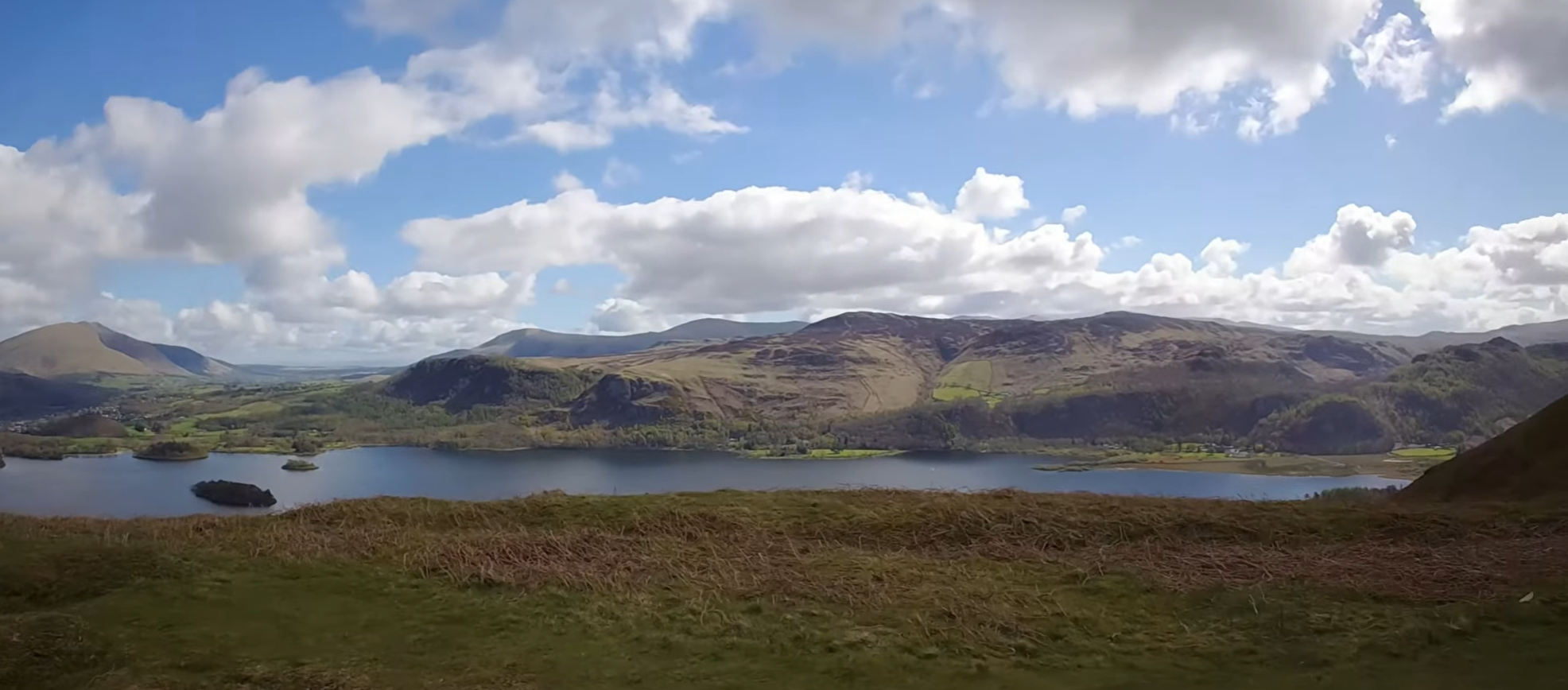
Point of Interest — The Summit View: From the summit the full circuit you are running is laid out in miniature. Derwentwater stretches north, all four islands visible at once — Derwent Isle nearest the western shore, Lord’s Island once home to the Jacobite Earls of Derwentwater, Rampsholme with its Norse name meaning “wild garlic island,” and St Herbert’s Island at the centre where a 7th-century Christian hermit built his cell in 685 AD. Keswick is visible at the northern end. To the northeast, Blencathra’s distinctive saddle (868m) is unmistakable. To the north, Skiddaw fills the sky. South, Borrowdale curves into the central fells. East across the lake, Walla Crag and the route of your return are already visible. West, the Newlands Valley — one of the most beautiful and least-visited in Lakeland — drops away in secret farmland.
The name “Catbells” derives from “Cat Bields” — old dialect for “shelter of the wild cat.” Wild cats disappeared from Cumbria centuries ago, but the name preserves a memory of a wilder fell. Catbells is one of the 214 fells catalogued by Wainwright; summiting all 214 is the challenge known as “doing the Wainwrights,” a pursuit that has occupied tens of thousands of walkers over the past seventy years. This is one of the most-visited of the 214 — and among the best.
From the summit the ridge continues south briefly toward Hause Gate, the narrow col connecting Catbells to Maiden Moor. The route descends east from the summit toward Manesty — follow the path carefully as multiple lines exist near the top.
Runner’s Note: The first section of Skelgill Bank is runnable for strong fell runners — short stride, lean forward, use your arms. The gradient eases briefly at the 150m shoulder before steepening again. Run what you can, hike what you can’t. Save energy for the final push above 200m which is the hardest section.
Descent into Manesty
Mile 5 is the most dramatic descent of the route — 308 metres lost in a single mile, dropping from the summit area down the eastern and southern flanks of Catbells into the open ground of Manesty Park. The upper section of the descent is steep and stony, requiring controlled footwork and concentration. The path is clear but loose in places; the temptation to open up on tired legs should be resisted until the gradient eases below 200 metres.
As you descend, the character of the landscape shifts completely. The exposed rocky fell gives way to open bracken slopes, then to the mixed woodland fringe of Manesty. The western shore of Derwentwater appears ahead and slightly below — the Chinese Bridge visible at the lake’s southern head, the broad valley of Borrowdale opening to the south. The transition from high fell to enclosed valley is rapid and striking.
Point of Interest — Manesty Park: Manesty Park is a National Trust owned area of open ground and mixed woodland at the southwestern corner of Derwentwater. The Cumbria Way long-distance path runs through it, and the area has a wild, transitional quality — neither the managed lakeside parkland of Brandelhow to the north nor the deep woodland of the Borrowdale approach to the south. The name Manesty is Old English, possibly derived from “man’s pasture” — suggesting ancient grazing use of this open ground between fell and forest.
The descent ends at lake level near the Chinese Bridge — the graceful single-arch footbridge over the River Derwent at the head of the lake, so called for the shallow oriental profile of its arch. This bridge is the route’s pivot point: fell behind you, eastern shore ahead. The path here may be waterlogged after heavy rain — the southern head of Derwentwater is notorious for flooding when the lake level is high.
Runner’s Note: The Manesty descent is the most technically demanding running on the route. Short, quick steps on the upper rocky section; let gravity do more work as the gradient eases below 250m. Your quads have absorbed the summit and will feel this descent — the saving grace is that everything from here to the finish is flat or gently downhill.
Manesty to the Southern Lakeshore
Having crossed the Chinese Bridge, the route moves east through Manesty and begins tracking the southern and eastern approach to the lake. This mile is a recovery mile — gently undulating, well-surfaced, the hardest terrain of the route now firmly behind you. The path winds through the open ground and woodland fringe of Manesty before reaching the southern lakeshore proper, where the Lodore Falls Hotel marks the approach to the lake’s southeastern corner.
The valley closes in briefly here — the entrance to Borrowdale is to the south, its flanks dark with conifer and native woodland. Castle Crag, the smallest of Wainwright’s 214 fells at just 298 metres, is visible as a distinctive rocky knoll in the valley throat. Shepherd’s Crag on the eastern wall of Borrowdale is one of the most famous rock climbing venues in England — generations of British climbers have made their first routes on its walls.
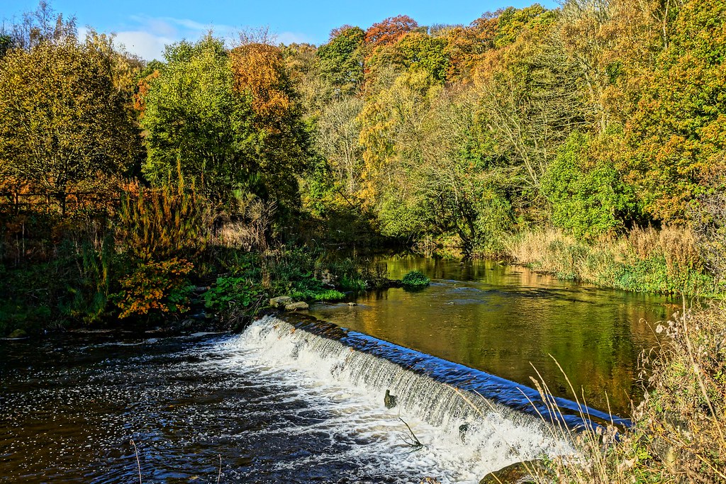
Point of Interest — Lodore Falls: A short detour at the end of this mile leads to Lodore Falls, where Watendlath Beck tumbles approximately 28 metres over a series of rocky outcrops from the hanging valley of Watendlath above. The falls are most spectacular after heavy rain — in a dry spell they can be little more than a trickle. Robert Southey, who lived in Keswick from 1803 until his death in 1843 as Poet Laureate, wrote his famous comic poem The Cataract of Lodore about these falls — a breathless onomatopoeic cascade of verbs mimicking the sound of falling water that has been recited aloud by schoolchildren ever since. The Lodore Falls Hotel beside the falls is the first refreshment opportunity since Keswick and well-placed for those who need fuel for the return leg.
Launching onto the Eastern Shore
The eastern shore path begins here — and in this direction, after the summit and descent, it is a gift. Almost entirely flat, well-surfaced gravel track and lakeshore path, heading north with the water immediately to your right. This is the famous eastern shore of Derwentwater, whose combination of ancient woodland, dramatic fell backdrop and direct lakeshore access makes it one of the most celebrated walking paths in England.
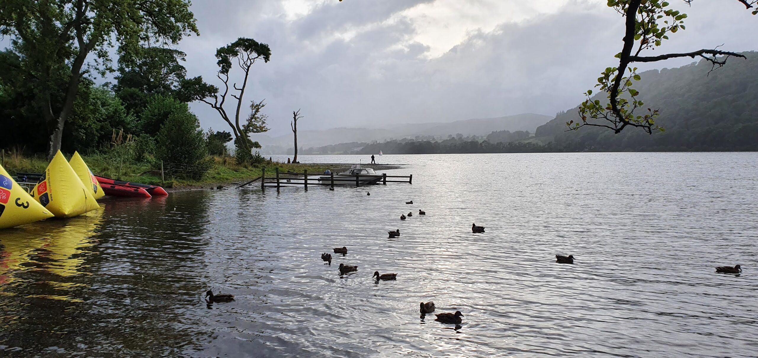
The path moves north past the first of the eastern shore landing stages, picking up the line of the Keswick Launch ferry route. The four historic vessels of the Keswick Launch Company — some dating from the 1920s and 30s — serve seven stops around the lake on a hop-on, hop-off basis. One vessel, the Lady Derwentwater (built 1926), appeared in the 1974 film of Swallows and Amazons.
Point of Interest — Derwentwater’s Islands: Running north along the eastern shore, all four of Derwentwater’s islands come into view in succession. St Herbert’s Island in the centre — named for the 7th-century hermit who built his cell there in AD 685 and became a disciple of St Cuthbert of Lindisfarne. Lord’s Island near the western shore — once home to the Earls of Derwentwater, whose Jacobite sympathies led to the family’s forfeiture and execution in 1716; only foundations remain. Derwent Isle — the only inhabited island, a National Trust property open to visitors just five days a year. Rampsholme Island — from Old Norse meaning “wild garlic island.” Together they give Derwentwater its distinctive scattered, picturesque character.
Runner’s Note: This is your recovery stretch — use it. The surface is excellent, the gradient negligible. After Catbells your legs deserve this. Set a comfortable rhythm and enjoy the views across the lake to the fell you’ve just crossed.
The Eastern Shore — Deep Woodland
This mile moves through the eastern shore’s most enclosed and atmospheric woodland section — the lower flanks of Walla Crag pressing down to the right, the lake opening through the trees to the left. The woodland here is ancient SSSI-designated Atlantic oak — twisted, moss-draped sessile oaks supporting exceptional biodiversity including red squirrels, pied flycatchers, wood warblers, and one of the richest lichen assemblages in the north of England.
The path passes through the broad bay of the eastern shore before reaching Barrow Bay and the next landing stage. Here, Great Wood — the National Trust-managed woodland covering the lower slopes of Walla Crag — begins properly. Great Wood is a significant red squirrel conservation site, and the thick woodland canopy in late spring makes it particularly beautiful for running. The crack of a greater spotted woodpecker against a dead oak and the piping alarm call of a nuthatch are the characteristic sounds of this section.
Point of Interest — Walla Crag: Rising above the woodland to the right, Walla Crag (379m) offers one of the finest viewpoints over Derwentwater — arguably superior even to Catbells for the aerial perspective it gives over the lake. A clear path leads up from the Great Wood to the summit and can be incorporated as a diversion adding approximately 2.5km and 300m of ascent. Walla Crag’s name derives from Old English “weall” (wall), describing the sheer rock faces of its eastern side. The crag is a nesting site for peregrine falcons — look and listen for them above the treeline.
Calfclose Bay & Ashness Gate
The path arrives at Calfclose Bay — a small quiet inlet where the route dips close to the shoreline. At the water’s edge look for the National Trust Centenary Stone, a large boulder of Borrowdale volcanic rock sawn in half and carved with concentric rings across ten segments, commissioned in 1995 to mark 100 years of the National Trust. Depending on the lake level — which fluctuates dramatically through the year — it may be standing clear on the shore or partially submerged.
Point of Interest — Ashness Gate & the View to Catbells: From Ashness Gate jetty, looking west across the lake, Catbells is directly in front of you — its summit the point you stood on four or five miles ago. The perspective from the eastern shore, looking across the full width of Derwentwater to the fell, is one of the classic Lake District views. The boat landing here is named Ashness Gate after the road above, which leads to the famous Ashness Bridge — a tiny packhorse bridge that appears on more biscuit tins and tea towels than almost any other spot in England — and beyond to Surprise View, a panoramic lookout over Derwentwater and Bassenthwaite Lake.
The path continues north, with the dark Scots pines of the northern woodland beginning to replace the oak woodland underfoot. A section of boardwalk carries the path over waterlogged ground near the shore. Ahead, through the trees, the outline of Keswick begins to become visible at the lake’s northern end — that first sight of the town after the long eastern shore is one of the quiet pleasures of this direction.
Friar’s Crag
The path curves out onto Friar’s Crag — the small wooded promontory that is one of the most celebrated viewpoints in England. The name derives from the medieval monks who set out from this point by boat on pilgrimage to St Herbert’s Island, visible in the centre of the lake. The crag is clothed in ancient Scots pine and stands like a natural platform above the water, the view south down the full length of Derwentwater arguably the most photographed in the Lakes.
At the crag stands the Ruskin Memorial — a block of Borrowdale volcanic stone erected in October 1900, shortly after the death of John Ruskin. The art critic and philosopher described this view as one of “the three or four most beautiful in Europe,” recalling being brought here by his nurse aged five in 1824 as one of his earliest memories. Having run the full circuit and stood on the summit of Catbells, you have now seen this lake from every angle — and you understand why Ruskin’s memory held it as it did.
Point of Interest — Canon Rawnsley: A second memorial on Friar’s Crag commemorates Canon Hardwicke Rawnsley, who died in 1920. Rawnsley was vicar of Crosthwaite Church in Keswick, a prolific author, fierce campaigner against Victorian development of the Lakes, and — most significantly — co-founder of the National Trust in 1895 alongside Octavia Hill and Robert Hunter. Friar’s Crag and Calfclose Bay were purchased by public subscription as his memorial. The stone at Brandelhow (mile 2 of this route) and the memorial here bookend the western and eastern shores — both monuments to the single most influential figure in the conservation of this landscape.
From Friar’s Crag the path continues north, passing the Keswick boat landings — home of the Keswick Launch Company, which has operated on Derwentwater since 1935 — and the Theatre by the Lake, Cumbria’s only producing theatre, opened in 1999 in one of the most enviably-situated cultural venues in England. The return to Keswick is now minutes away.
Back to Moot Hall
The final partial mile follows the lakeshore north and then heads back up into Keswick, arriving at Market Square and the Moot Hall — your starting point. The contrast between the silent ridge of Catbells and the bustle of the Market Square is one of the peculiar pleasures of this route: you leave from the centre of a busy tourist town, cross a lake, climb a fell, and return to find the same one-handed clock ticking and the same ice cream queues forming. The mountain was real. The town is waiting. Both are part of the same landscape.
Post-Route — Wildlife SummaryThroughout the route, priority sightings include: red squirrel (western shore woodland, Great Wood), osprey (summer, fishing over the lake — regular visitors since the early 2000s), peregrine falcon (Walla Crag), red kite (over fell and lakeshore), dipper (River Derwent at Portinscale), common sandpiper (lakeshore, April–August), pied flycatcher (Great Wood, May–July), common tern (nesting on the islands, summer), and arctic char (in the lake — a glacial relict species isolated here since the end of the last Ice Age, one of only a handful of English populations).
Runner’s Final Note10.66 miles. 514 metres of climbing. Moot Hall to Moot Hall — west to Portinscale, south along the western shore, up Skelgill Bank, the summit, Manesty, Lodore, the eastern shore, Friar’s Crag, home. It is one of the finest anticlockwise circuits in the Lake District. The Dog and Gun on Lake Road has been welcoming mud-covered runners and walkers through its doors for over a century. You have earned it.
Leave a Reply